Making realistic Routes - GEO data.
Route Editor provides several tools for making realistic routes easier.
1. Marker Files
2. Map Layers
3. HGT terrain data import
If you are making imaginary route, you can skip this chapter.
Marker Files
Current version of Route Editor supports three types of marker files:
1. MKR MSTS file http://msts.steam4me.net/tutorials/mkr_googlemaps.html
2. KML file https://en.wikipedia.org/wiki/Keyhole_Markup_Language
3. GPX file https://en.wikipedia.org/wiki/GPS_Exchange_Format
MKR files are for peoples who grew up with MSTS Route Editor and can't live without MKR files. Everyone else should use KML or GPX file istead
Example: how to make KML/GPX file
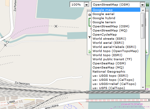
You can use http://www.gpsvisualizer.com/draw/
This site allows to draw points and ways on large number of map layers, including Google Maps Satelite.
Use 1. Button to draw points, or 2. Button to draw ways.
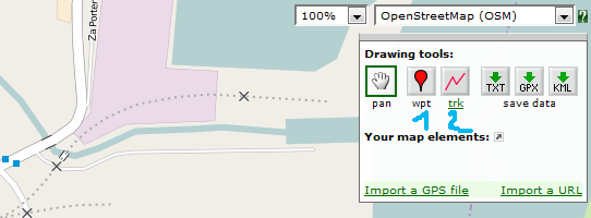
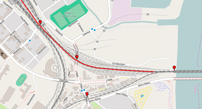
Draw some points and ways
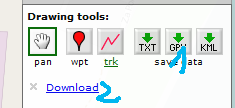
Use 1. to select file type and 2. to download it.
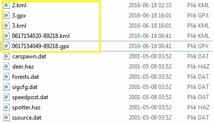
Place the file in route directory.
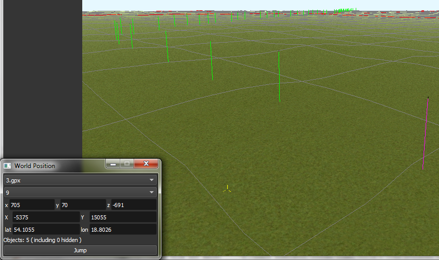
In World Position window select your file.
You can select file item and use Jump button to jump to item position.
Click menu View->Markers to show selected file items.
Map Layers
Map layer is better and faster solution than marker files if you want to create reaistic route.
1. Go to Geo Tools. Menu Tools->Geo or F3.
2. Click Load Map button.
3. Find Tile you want to load map layer and click on it.
4. In new window click Load and wait until map layer download is complete.
5. You can choose between bright and dark colors.
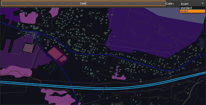
6. Close the window.
7. Click Show/H Map button.
8. Find Tile you want to show map layer and click on it.
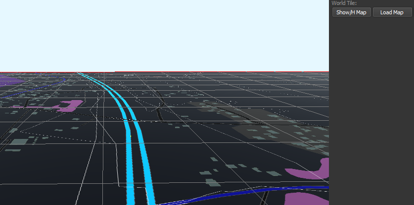
9. Don't load too many Tile maps at once.
HGT terrain data import
HGT terrain data import allows you to easly create realistic terrain.
You need to download proper HGT files manually. Example site where you can get them: http://e4ftl01.cr.usgs.gov/SRTM/SRTMGL1.003/2000.02.11/
If you don't know which files to download - read below.
1. Set geoPath in settings to directory where you have your HGT files. See: Editing settings.txt
2. Go to Geo Tools. Menu Tools->Geo or F3.
3. Click Load Height button.
4. Find Tile you want to load terrain data and click on it.
5. In new window click Load button.
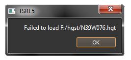
6. If proper HGT doesn't exist: message box will tell you name of the file you need to download. Close editor and download missing files.
7. Close the window.
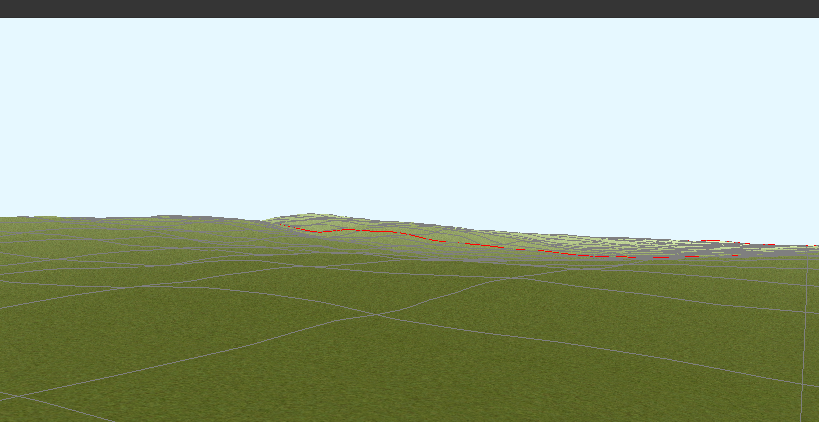
8. Enjoy realistic terrain.
Route Editor provides several tools for making realistic routes easier.
1. Marker Files
2. Map Layers
3. HGT terrain data import
If you are making imaginary route, you can skip this chapter.
Marker Files
Current version of Route Editor supports three types of marker files:
1. MKR MSTS file http://msts.steam4me.net/tutorials/mkr_googlemaps.html
2. KML file https://en.wikipedia.org/wiki/Keyhole_Markup_Language
3. GPX file https://en.wikipedia.org/wiki/GPS_Exchange_Format
MKR files are for peoples who grew up with MSTS Route Editor and can't live without MKR files. Everyone else should use KML or GPX file istead
Example: how to make KML/GPX file
You can use http://www.gpsvisualizer.com/draw/
This site allows to draw points and ways on large number of map layers, including Google Maps Satelite.
Use 1. Button to draw points, or 2. Button to draw ways.
Draw some points and ways
Use 1. to select file type and 2. to download it.
Place the file in route directory.
In World Position window select your file.
You can select file item and use Jump button to jump to item position.
Click menu View->Markers to show selected file items.
Map Layers
Map layer is better and faster solution than marker files if you want to create reaistic route.
1. Go to Geo Tools. Menu Tools->Geo or F3.
2. Click Load Map button.
3. Find Tile you want to load map layer and click on it.
4. In new window click Load and wait until map layer download is complete.
5. You can choose between bright and dark colors.
6. Close the window.
7. Click Show/H Map button.
8. Find Tile you want to show map layer and click on it.
9. Don't load too many Tile maps at once.
HGT terrain data import
HGT terrain data import allows you to easly create realistic terrain.
You need to download proper HGT files manually. Example site where you can get them: http://e4ftl01.cr.usgs.gov/SRTM/SRTMGL1.003/2000.02.11/
If you don't know which files to download - read below.
1. Set geoPath in settings to directory where you have your HGT files. See: Editing settings.txt
2. Go to Geo Tools. Menu Tools->Geo or F3.
3. Click Load Height button.
4. Find Tile you want to load terrain data and click on it.
5. In new window click Load button.
6. If proper HGT doesn't exist: message box will tell you name of the file you need to download. Close editor and download missing files.
7. Close the window.
8. Enjoy realistic terrain.
Contact me: pgadecki(xD)gmail.com